(Photo by Calvin Shepherd - Use By Permission)
Alderson West Virginia - A History

© Property of Min7th Productions 2012
Roads
On
of
the
first
problems
which
faced
the
county
court
of
Greenbrier
County
after
the
county
was
organized
was
roads.
The
most
pressing
need
for
transportation
was
across
the
mountains
to
the
East.
In
1781
the
Sheriff
was
directed
to
let
a
contract
to
build
a
road
from
the
courthouse
to
Warm
Springs,
from
twelve
to
fifteen
feet
wide,
to
be
finished
by
October
1782.
It
was
to
be
paid
for
with
fifty
tons
of
hemp.
Other
roads
were
started
and
tithables (taxpayers) were working on the roads in 1783.
The
first
mention
in
Greenbrier
County
Records
of
a
road
in
the
area
now
Alderson
is
in
Order
Book
A,
January
16,
1787.
It
reads,
"Joseph
Soape
is
appointed
overseer
to
open
a
road
from
John
Alderson
to
the
last
fork
of
Wolf
Creek
above
the
said
Soaps,
and
it
is
ordered
that
all
tithables
in
Graham's company do attend and assist the said surveyor in clearing and repairing said road when required." So, the first road was up Wolf Creek.
When
Monroe
County
was
formed
in
1799,
one
of
the
first
concerns
was
road,
and
the
development
of
the
same
first
road
was
continued.
Five
men,
Joseph
and
George
Swope,
L.
Lowe,
John
Alford,
and
Thomas
Alderson
were
"to
view"
from
Alderson's
Ferry
to
Union
by
the
most
direct
course.
This was August, 1799.
The
first
authentic
map
of
Virginia
was
made
by
Herman
Boye
in
1828.
It
shows
one
road
through
Alderson's
Ferry
from
Union
to
Blue
Sulphur
and
North. It crossed Greenbrier at the Ferry and crossed Muddy Creek about the location of Palestine.
Evidently,
a
road
was
being
opened
in
1813
down
the
Greenbrier
to
New
River.
Three
road
commissioners
in
charge
were
appointed
by
Monroe
County
Court.
They
were
Joseph
Alderson,
David
Graham
and
William
Hinchman.
This
road
is
not
on
the
Boye
map
of
1828,
and
must
never
have
been completed.
In
1836
the
Red
Sulphur
and
Blue
Sulphur
Turnpike
was
incorporated.
This
was
a
toll
road
which,
according
to
records,
was
examined
on
July
30,
1840 by the County Court.
In
1838
another
corporation,
Indian
Draft
Turnpike,
was
formed
to
join
the
Red
Sulphur
and
Blue
Sulphur
Turnpike.
This
road
was
from
Salt
Sulphur.
It
was
granted
permission
to
cross
the
Greenbrier
at
Alderson's
Ferry
by
ferry,
and
no
bridge
was
required.
Local
men
who
were
among
incorporators were Joseph Hill, Joseph Alderson, John Alderson, Andrew Miller, William Ellis and James Hill.
Records
are
too
vague
to
attempt
to
trace
any
other
roads
out
of
town.
It
appears
the
sole
road
that
was
in
regular
use
was
the
Union-Blue
Sulphur
road. No permanent record of roads either up or down the river was located.
A
map
by
M.
W.
White
in
1871
appeared
in
Mitchell's
New
General
Atlas
of
that
year.
In
addition
to
the
road
previously
mentioned
there
is
another
road
up
the
river
across
Muddy
Creek
Mountain
about
where
the
mountain
road
is
now.
Still
another
road
left
Palestine
and
crossed
the
mountain
to
the
north.
No
road
is
shown
down
the
river
from
Alderson's
Ferry.
Both
Muddy
Creek
Mountain
roads
joined
other
roads
going
to
Lewisburg
and
to
the north, but did not go into Ronceverte. It is not know when the Muddy Creek road was built.
A
map
of
Greenbrier
County
by
H.
H.
Harrison
and
J.
O.
Handley
in
1887
shows
all
road
leading
out
of
Alderson
in
greenbrier
to
be
about
where
they
are now.
The
West
Virginia
State
Road
Commission
does
not
keep
a
historical
file
of
local
highways.
Mr.
Harry
Venable
of
the
Lewisburg
District
office
furnished
information
of
the
improvements
to
the
various
state
road
serving
Alderson.
The
Wolf
Creek
road
to
Pickaway
was
graded
and
based
in
1925
and
finished
in
1927
to
Griffith's
Creek,
and
between
1928
and
1930,
completed
to
Hinton.
Route
12,
North
to
Alta
connecting
with
U.
S.
Route
60, roughly followed the old Muddy Creek Road and up Mill Creek. It was finished to Brant in 1938 and on to Ronceverte in 1942.
The
big
road
question
which
now
has
section
fighting
section,
town
against
town,
and
faction
against
faction,
is
the
location
of
Interstate
64.
This
road
was
original
planned
to
traverse
the
State
about
parallel
to
U.
S.
60,
going
through
Fayette
and
Western
Greenbrier
and
white
Sulphur
Springs.
In
order
to
get
an
additional
Interstate
highway
north-south
from
Charleston-Beckley
area
to
Pennsylvania,
Interstate
64
was
planned
to
be
re-routed
starting
at
Beckley,
going
east
to
the
Virginia
line
near
White
Sulphur
Springs.
The
re-routed
Interstate
64
would
go
close
to
Hinton,
Alderson
and
Ronceverte
and
the
new
route
was
vigorously
applauded
by
those
communities.
There
have
been
five
different
routes
surveyed.
On
of
them
touches
South
Alderson
near
Copeland's
Garage
and
around
Flat
Top
Mountain
and
east
up
the
Greenbrier.
This
survey,
presently,
presently
seems
to
be
the most favored.
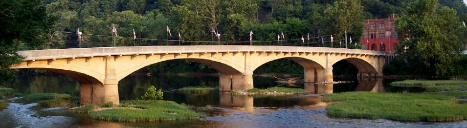
From the time Alderson was but a wilderness the Greenbrier was forded above and below the present bridge.
In
1789
by
legislative
grant
from
the
Virginia
assembly
to
Elder
John
Alderson
a
ferry
across
the
river
was
established.
This
ferry
was
just
below
the
present location of the railroad station. On old maps the place is named Alderson's Ferry.
Greenbrier
County
Court
records
show
that
the
County
Court
considered
building
a
bridge
across
the
river
in
the
July
term
1878.
It
approached
the
Monroe
County
Court
to
bear
one-half
of
the
expense
estimated
at
$14,000.
The
two
county
courts
seemingly
did
not
get
along
very
well,
and
it
was
not
until
the
July
term
1881
that
agreement
was
reached.
Two
sub-commissioners
of
the
Courts
were
appointed,
Samuel
Price
and
James
Withrow,
who
agreed
on
specifications,
engineering
and
letting
of
the
contract.
The
Pittsburgh
Bridge
Company,
Pittsburgh,
Pa.,
got
the
contract
to
build
the
bridge
for
$11,900.00.
They
must
have
quickly
built
the
bridge
by
1882,
as
in
that
year
an
abutment
was
not
satisfactory
according
to
the
court
records.
The
iron
bridge
was
frequently
in
disrepair.
The
minutes
of
the
Town
Council
show
the
Council
was
often
fussing
at
the
two
County
Courts
to
do
something
about
it.
On
August
8,
1913,
the
Council
authorized
consultation
with
the
County
Courts
about
constructing
a
new
bridge
of
concrete.
In
February
1914,
the
Greenbrier
County
Court
ordered
the
Town
of
Alderson
to
repair
the
old
iron
bridge.
Town
Council
was
indignant
and
flatly
refused
saying
the
town
had
not
built
the
old
bridge,
had
no
authority
to
repair
the
bridge,
that
townspeople
had
paid
taxes
to
help
build
all
other
county bridges, and finally the river was not the property of the town, but was State property.
In
April
1914,
the
County
Courts
of
Greenbrier
and
Monroe
agreed
to
build
a
new
bridge
without
sidewalks.
On
May
5,
1914,
Mayor
McNeer
issued
a
proclamation
for
a
bond
issue
election
of
from
$2,000.00
to
$3,000.00
to
be
held
May
26.
the
vote
was
191
for,
2
against,
for
one
sidewalk,
and
186
for,
2,
against,
for
two
sidewalks.
The
Concrete
Steel
Bridge
Co.,
Clarksburg,
W.
Va.,
had
a
contract
to
build
the
bridge
for
$20,600.00.
On
October
30,
1914,
a
contract
was
made
with
the
company
to
build
the
two
sidewalks
for
$2900.00.
So,
the
roadway
belonged
to
the
State
and
the
sidewalks belonged to the town.
The
bridge
has
served
for
50
years.
It
is
narrow,
dilapidated
and
a
danger
to
pedestrians.
The
sides
are
just
high
enough
so
that
automobile
passengers cannot see the magnificent view, east of west, of the beautiful Greenbrier.
A new bridge is badly need but cannot be planned until a final decision is made of the location of Interstate Highway 64.
Main Index
The contents contained in this series is copyrighted and the sole property of The Greenbrier Historical Society - Lewisburg, WV Used by permission - November 18, 2008
The History of Alderson, West Virginia
From The Journal Of The Greenbrier Historical Society On Alderson, West Virginia
Written by Kenneth D. Swope - Compiled and Transcribed by Barry Worrell