(Photo by Calvin Shepherd - Use By Permission)
Alderson West Virginia - A History

© Property of Min7th Productions 2012
The History of Alderson, West Virginia
From The Journal Of The Greenbrier Historical Society On Alderson, West Virginia
Written by Kenneth D. Swope - Compiled and Transcribed by Barry Worrell
Alderson Community
This
is
a
history
of
the
Alderson
community.
A
definition
of
the
community
is
that
area
comprising
the
incorporated
town
of
Alderson,
West
Virginia,
the
unincorporated
village
known
as
Palestine
to
the
Northeast,
the
settlement
known
as
Glen
Ray,
and
the
Federal
Reservation
on
which
is
located
the Federal Reformatory for Women, to the West.
Roughly,
the
Alderson
Community
is
a
triangle
from
Palestine
south
along
the
base
of
Muddy
Creek
Mountain
to
the
base
of
Flat
Top
Mountain
across
the
Greenbrier
River
above
Camp
Greenbrier,
west
to
the
Reformatory
and
northeast
from
the
Reformatory
to
Palestine.
It
is
in
the
southeastern
section
of
West
Virginia and parts of it are in Greenbrier, Monroe and Summers Counties.
The
elevation
is
1551
feet
at
the
Post
Office.
The
exact
location
is
37°
43’
N
latitude,
80°
38’
W
longitude.
The
1960
census
gives
the
population
in
the
Town
of
Alderson
to
be
1225;
774
in
North
Alderson
and
451
in
South
Alderson.
To
this
can
be
added
probably
500
living
outside
the
corporate
limits
and
the
approximately
600
unwilling
inmates
of
the
Federal
Reformatory
for
Women.
Thus,
the
total
population
of
the Alderson community is about 2300.
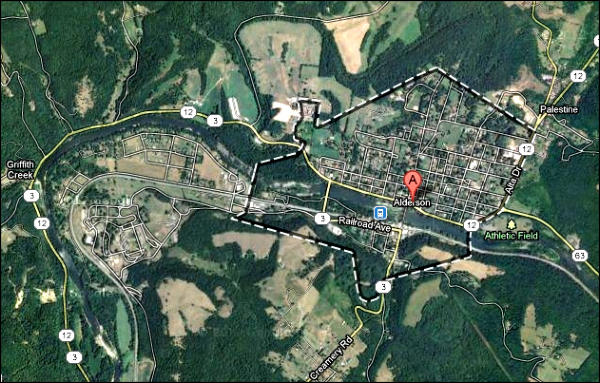
The
community
is
divided
by
the
Greenbrier
River
running
east
to
west,
forming
the
Greenbrier-Monroe
Counties’
boundary.
Greenbrier
County
is
on
the
north
side
with
about
two-thirds
of
both
area
and
population,
and
Monroe
County
is
on
the
South
side
of
the
river.
Below
the
town
to
the
west
is
the Summers County section.
The
community
is
located
in
the
valley
of
the
Greenbrier
River,
much
of
it
flat
alluvial
land.
The
northern
part
of
the
town
is
a
gentle
slope
beyond
which
on
Muddy
Creek
is
the
village
of
Palestine,
about
one
and
one-half
miles
from
the
business
section.
Along
the
south
side
of
the
Greenbrier
is
the
Chesapeake
and
Ohio
Railway.
Parallel
to
the
railroad
on
the
Monroe
side
for
two
blocks
is
the
main
business
section.
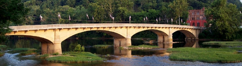
North
and
South
Alderson
are
joined
by
a
narrow
concrete
bridge
built
in
1914
across
the
Greenbrier.
Muddy
Creek
Mountain
overlooks
the
community
to
the
east,
Flat
Top
Mountain
to
the
south,
and
magnificent
Keeney's
Mountain
is
a
few
miles
to
the
west.
Greenbrier
River
and
the
surrounding
mountains
give
the
Alderson
community
one
of
the
most
beautiful
natural
settings
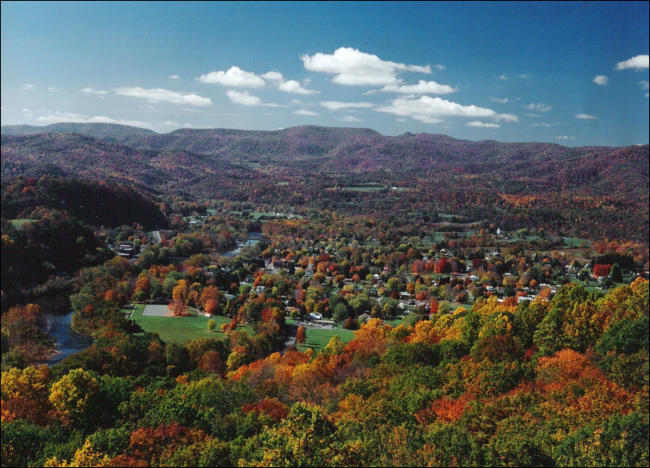
imaginable. (Click on photo for larger view)
The
primitive
possessors
of
all
the
land
were
the
Indians
who
used
it
primarily
for
hunting.
There
is
no
record
of
there
having
been
an
Indian
settlement
in
the
section
although
their
weapons
and
artifacts
facts
can
still
be
found.
The
Indians
did
have
villages
on
New
River
in
Summers
County
and
the
Smithsonian
Institution
in
1948
explored
the
Bluestone
Reservoir
area
before
it
was
flooded
by
Bluestone
Dam,
from
Narrows,
Virginia to Sandstone.
It
was
found
that
historic
and
pre-historic
Indians,
including
the
Adena
mound-builders,
had
lived
in
the
New
River
Valley
for
centuries
before
civilized
history of this continent. Nine villages, mounds, rock-shelters, ceramics and a vast collection of artifacts were found.
It
is
not
unreasonable
to
suggest
that
the
Alderson
Valley
may
also
have
been
the
ancient
home
of
pre-historic
Indians.
Solecki,
the
Smithsonian
archaeologist,
said
more
explorations
should
be
made
in
West
Virginia
as
he
had
but
"scratched
the
surface."
An
Archaeological
Survey
of
Two
River
Basins in West Virginia. Rulph S. Solecki, Smithsonian Institution, l948. West Virginia History Quarterly, July, 1949, Vol. X, N0. 4
The
Indians
traveled
far
and
wide.
Wild
game
-
buffalo,
elk,
bear,
deer,
fish
and
smaller
animals
were
plentiful.
The
animals
made
paths
and
the
Indians
followed
the
same
paths.
These
paths
became
veritable
Indian
highways.
One
of
the
most
famous
was
the
great
Seneca
Trail
or
Warriors
Path.
One
branch
of
it
passed
directly
through
Alderson
following
the
river.
(This
trail
ran
from
the
New
York
-
Pennsylvania
region
to
the
North
Carolina
region.)
Another
great
trail
crossed
the
Greenbrier
at
the
mouth
of
Griffith's
Creek
and
across
Keeney’s
Knob
from
Monroe
County
and
the
east.
There
were
so
many
Indian
trails
it
is
impossible
to
trace
them
all.
When
the
vast
wilderness
began
to
be
invaded
by
white
men,
the
adventurers, explorers, traders and settlers followed the same Indian paths.
No
one
knows
who
the
first
white
man
was
to
tread
the
soil
now
Alderson.
That
early
visitor
may
have
been
an
adventurer,
trader,
or
a
criminal
fleeing
a
harsh
justice.
These
early
Wanderers
had
no
sense
of
the
historical
importance
of
their
travels.
They
wrote
nothing
and
probably
many
of
them were unable to write.
The
French
claimed
the
entire
Mississippi
basin
of
which
the
Kanawha,
New
and
Greenbrier
valleys
are
a
part.
The
French
relied
upon
Jesuit
priests
for
exploration,
who
in
their
long
black
robes
carried
the
Cross
to
the
savages
and
represented
the
Crown
of
France.
The
Jesuits
were
educated,
dedicated
explorers
and
missionaries
of
the
Catholic
faith.
They
kept
records
which
have
been
published
in
a
73
volume
set
entitled
Jesuit
Relations.
This
writer
has
searched
the
records
and
finds
no
authority
for
the
supposition
that
the
Jesuits
came
closer
to
the
Greenbrier
Valley
than
Point
Pleasant on the Ohio.
Main Index
The contents contained in this series is copyrighted and the sole property of The Greenbrier Historical Society - Lewisburg, WV Used by permission - November 18, 2008
(Click on photo for larger view)