


1928 - Alderson High School - 1968


Annexation of North Alderson
From The History Of Alderson
As
recorded
elsewhere,
the
C
&
O
began
serving
Alderson
in
1873,
and
the
population
rapidly
began
to
increase.
In
1880
the
population
was
478
according
to
the
U.
S.
Census.
The
first
bridge
spanned
the
river
in
1881
and
the
little
town
was
ready
to
assume
civic
responsibility.
It
became
an
incorporated
town
in
1881.
The
corporation
of
Alderson
was
on
the
south
side
of
the
river
only
as
most
of
the
north
side
was
farming land belonging to members of the Alderson family.
It
was
twenty-three
years
later
before
North
Alderson
proposed
a
municipal
marriage
with
the
corporation.
On
December
29,
1904,
a
committee
from
the
north
side
met
with
Council
to
discuss
the
annexation.
The
matter
was
debated
and
no
action
taken.
Four
days
later,
on
January
2,
1905,
a
petition
to
the
Town
Council
signed
by
J.
M.
Alderson,
G.
K.
Gwinn,
William
H.
Hamlett,
G.
E.
Bare
and
M.
Levy
was
presented
to
Town
Council
asking
that
north
Alderson
be
annexed
to
the
town.
An
Election
was
held
January
27,
1905
on the question The results were:
South Alderson: For incorporation - 50; Against - 20.
North Alderson: For incorporation - 55; Against - 35
.
On
March
23,
1905,
the
vote
was
canvassed
by
the
Town
Council
and
North
Alderson
was
officially
married
to South Alderson, subject to approval of the Circuit Court of Monroe County - which was granted later.
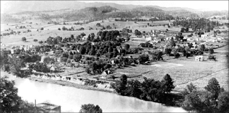
North
Alderson
was
brought
into
the
corporate
limits
of
the
town,
about
the
time
this
photo
was
taken
looking
northwest
from
Reservoir
Hill.
Visible
towards
the
center
of
the
picture
are
the
Old
Greenbrier
Baptist
Church,
the
Alderson
Academy,
and
the
Public
School
building
(with
small
belfry).Several
folks
are
out
practicing
on
the
baseball
diamond
in
the
right
foreground
and
just
about
everyone
has
a
cornfield
in
his
back
yard Photo by J. W. McClung. (Click on photo for larger view)
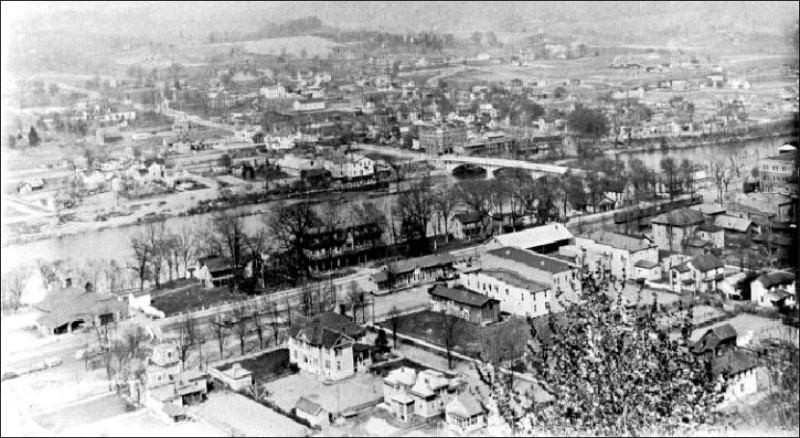
This
1917
photo
shows
a
grown-up
town,
North
and
South
of
the
river.
Prominent
on
the
south
side
are
the
passenger
and
freight
stations,
the
Alderson
House
Hotel,
and
the
main
business
district.
The
old
livery
stable
in
the
lower
left
has
already
become
the
Alderson
Garage,
and
according
to
the
poster,
the
circus
is
due
soon.
North
of
the
"new
bridge"
the
Alderson
National
Bank
and
the
new
brick
Public
School
building
dominates.
It
must
have
been
Sunday
when
Mr.
McClung
took
this
photo
as
no
pedestrian
or
vehicular
traffic
is
seen
except
at
the
depot. (Click on photo for larger view)
The
last
time
the
Town
of
Alderson
attempted
to
add
to
the
corporation's
area
was
in
an
election
held
June
3,
1941.There
were
nearly
1000
registered
voters
in
the
town
in
1940;
356
in
South
Alderson
and
618
in
North
Alderson
and
but
289
of
them
voted
in
the
election
to
take
into
the
corporation
the
area
bounded
by
Chase Street on the East, Route 54 South and East, and Hemlock Street on the north.
The
voters
inside
the
corporation
voted
to
take
in
the
section,
240
for
annexation,
49
opposed.
Evidently
the
voters
residing
outside
the
corporation
in
the
area
to
be
annexed
did
not
like
the
idea.
They
voted
30
to
10 against it. The election lost.
I
remember
my
mother
in
the
60s,
talking
about
an
annexation
that
did
happen
and
included
the
Alderson
people
from
east
of
Chase
street.
I
can’t
find
any
details
on
this,
but
if
I
do,
the
information
will
be
added
to
this page._Barry Worrell
The Most Recent Plan For Annexation
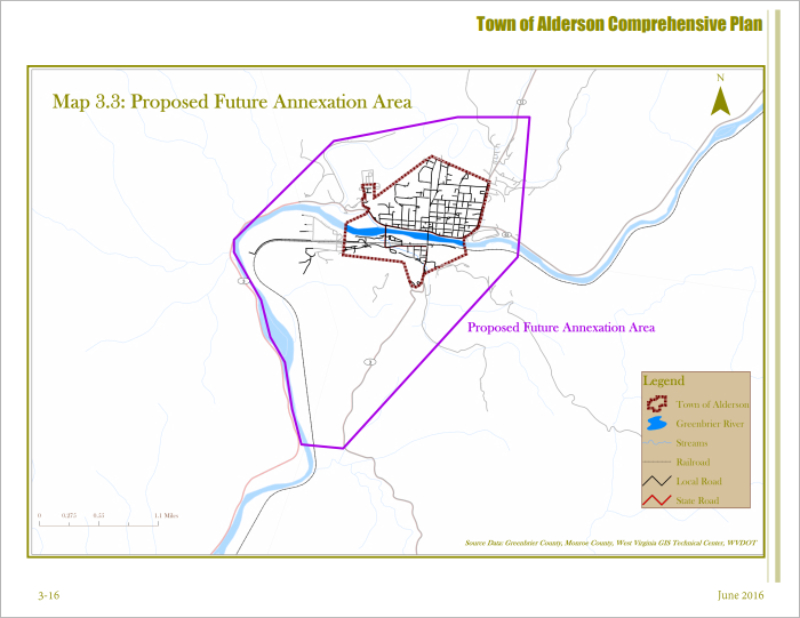
From The Town Of Alderson Comprehension Plan
This
diagram
shows
a
2016
plan
for
the
annexation
of
the
area
surrounding
Alderson.
As
you
can
see
by
the
purple
outline,
this
would
increase
the
size
of
Alderson
by
three
to
four
times.
The
discussion
lasted
for
a
while,
but
was
abandoned.
As
in
the
1941
plan,
when
it
was
voted
down,
not
all
were
in
favor
of
the
plan.
(Click
on
picture
for
larger view)