|
Question: Where is Kenney's Knob, Summers county,
West Virginia, U.S.A.--anyway?
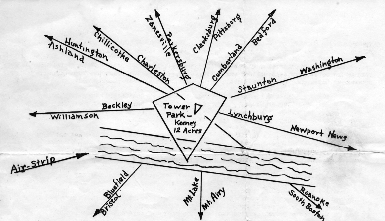
Well
one way to find it is by the directions (above) a few of our
well-known landmarks
(cities). Another way is: Wait until the proposed mountain-top
landing is actually cleared end completed (everybody's talking about it) and planes
come sliding in at the (ground) elevation of something like 3880 feet on
additional land available right near the 12acre Tower Park (above),
From the 90-foot tower, without the aid of glasses, forest fires are
being
spotted "50 miles by the fly of the crow" in the region of the Coal
River Valley, for
example, known to be a very important part of our southern West
Virginia coal fields. Same look, a bit northward, goes right into the "World's
Chemical Centre"--the Great
Kanawha Valley, e -regular beehive--all kinds of business.
Turning southward and you are seeing up the valley
of "the only river in the world according to the late Judge Sawyers, "that cuts clear
through a great mountain system"--the wonderful New River
rapidly coming under control in the nearly-completed. Bluestone Dam at Hinton.
Speaking of rivers: the meandering Meadow River, northward, through
the
farming, timbering, coaling regions of western Greenbrier has its
source right up here
where you are talking about landing your craft.
Then take the eastward look at limestone cliffs "mountain high"
being worked
down, in places, to powerful crushers and grinders such for example
as those of the
Acme Limestone Company on the Greenbrier (river) on the main line of
the C & 0 and
within ten air-miles of this--gliding-in-gracefully, port proposed,
in due time.
Yes look at this whole broad area--the limestone lands, the valleys
and hills,
among the forests, covered with the famous Greenbrier bluegrass--the
world's finest,
the highest in protein. First a field and then a forest of hardwoods
unsurpassed in
quality if even equaled on this side of the globe; and for the
protection of all this valuable timber the Forest Service Airplane
is on the alert. Suitable "forest" landings are few and far between. We need more landing-strips on these
"beautiful hills".
What will it cost to clear the air-strip of timber? Excepting
stumps, the
sale, most any kind of timber, should pay for the "clearing".
Dynamite, stump-pullers
and other machinery required to complete the job. Fifty to
seventy-five years ago
fifty cents and board the usual wages per day for work in any
clearing for corn.
From federal sources reported: "Also the (President's) commission
recommends
strengthening and improving of civilian aviation and goes into
details as to extensive
changes in governmental organizations which it believes necessary to
its program".
This "Fly Leaf" wings its way from "Mountain Ranger", Alderson,
Monroe County,
West Virginia. (June 1948).__ Will Stevens |